
Precision Forestry.
From Seedling to Harvest.
Enhance your reforestation and timber management with our professional aerial support. We utilize advanced drone technology for precise monitoring and data collection. Our team is committed to sustainable practices and efficient resource management. Partner with us to achieve your environmental goals.
At Buswell Drone Services, we provide full-lifecycle support for timber management and reforestation by solving the most difficult logistical and data-driven challenges. Utilizing our American-made Heavy Lift drones, we act as a "pack mule" in the sky, transporting bundles of saplings directly to planting teams on steep, remote terrain to increase daily planting counts while reducing crew fatigue. Beyond sapling transport, these workhorses streamline operations by flying rope for yarder layouts and delivering essential gear, cables, and spools to crews in inaccessible areas. For the data-driven side of your project, our Multispectral and Digital Imagery drones provide the "X-ray vision" needed to monitor land health. We perform post-planting audits, map project progress, and track growth to identify crop loss with centimeter-level accuracy. By capturing NDVI (multispectral) data, we can detect moisture stress, nutrient deficiencies, or disease in young stands weeks before they are visible to the human eye. This allows for precision spot treatments of fertilizer or herbicides, ensuring your reforestation efforts are safer, faster, and backed by actionable intelligence.
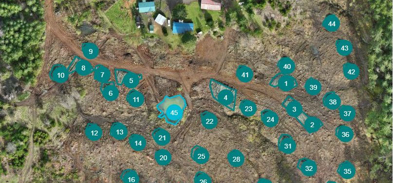
Managing timber in the Willamette Valley and the Coast Range means dealing with steep slopes, heavy slash, and impenetrable brush. Traditional field cruising only gives you a tiny sample size of your land's true condition. Using advanced multispectral sensors and AI, we digitize your entire unit. We replace guesswork with verifiable data, helping you hit your stocking requirements, optimize your spray budgets, and hold contractors accountable.
Core Operations


Built for the Pacific Northwest
We don't fly toy drones. Buswell Drone Services utilizes enterprise-grade aircraft designed for biological data capture. Steep-Slope Terrain Follow: Our drones automatically adjust altitude to maintain a perfect, consistent distance over extreme Oregon ravines and hillsides, ensuring your data is perfectly scaled. Dual-Sensor Payload: Captures stunning 20MP visual mapping alongside 4-band Multispectral data (Green, Red, Red Edge, Near-Infrared) in a single flight. GIS-Ready Deliverables: We don't just hand you a PDF. We deliver GeoTIFFs, KMLs, and Shapefiles that drop seamlessly into ArcGIS, QGIS, or your forester's existing workflow.
